Algonquins to Atoms Along the OttawaA history of life and development on the Ottawa River,
|
by Jeremy Whitlock | [en français] |
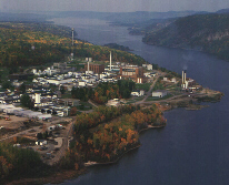
For over two centuries it was the gateway to a whole continent; one of history's important rivers. Today, the river and its history are little known to Canadians, beyond an association with the nation's capital built along its lower shores. Such is the irony that colours the story of the Ottawa River. Another example can be found in the upper reaches of the mighty river, where rugged country, isolation, and poor soil have restricted settlement to the same sparse pattern that existed a hundred years ago. Yet here, within the infinite pine forest, along the billion-year-old granitic shoreline, sits an immense and world-renowned scientific institution: Chalk River Laboratories, birthplace of the CANDU reactor.
At first sight one is struck by the apparent paradox. In fact, the presence of the country's flagship nuclear laboratory is oddly consistent with the river's legacy. For four hundred years the Ottawa River has been linked to one vital Canadian industry or another, from the fur trade, through the logging and lumber era, to the widespread development of hydro-electricity, and finally, the pioneering of nuclear power. The story of the Ottawa is a major part of this country's cultural and industrial heritage.
Aboriginal Cultures
But the story begins earlier than this. Well before the arrival of the first Europeans, the Ottawa was an important highway for commerce, cultural exchange, and transportation. Archeological sites on Morrison Island near Pembroke reveal a 5000-year-old culture that manufactured copper tools and weapons. Copper ore was extracted north of Lake Superior and distributed via the Ottawa throughout the forbidding Canadian Shield country, down to today's northern New York state. At this time the prehistoric river still drained much of the Great Lakes basin, a legacy of the recent Ice Age (today the Lake Erie route is the sole outlet for the basin).Two thousand years ago the river and its tributaries looked much like they do today, draining over 140,000 square kilometres of mostly Precambrian rock. Local pottery artefacts from this period show widespread similarities that indicate the continuing use of the river for cultural exchange throughout the Shield and beyond. Some centuries later the Algonquin tribe moved in and inhabited the islands and shores along the Ottawa, and by the 1600's the first Europeans found them well-established as a hunter-gatherer society in control of the river. The Algonquins called the river the "Kichesippi". The French colonials called it "La Grande Rivičre des Algoumequins", and quickly recognized its strategic potential as an entry point to the nether regions of the New World.
The Fur Trade
Over a thousand kilometres long, the Ottawa starts out in the flat highland due north of today's city of Ottawa, travels west to the Ontario/Québec border, and finally switches eastward and follows an ancient fault line (carved out by glacial meltwater) down to the St. Lawrence at the Island of Montréal. It was here at this confluence of the two mighty rivers that Samuel de Champlain, founder of Québec in 1608, set up the first "trading place" and thus initiated the great fur trade. The pelts of beaver and other wildlife were brought down the Ottawa in massive flotillas of birchbark canoes each Spring. Although only the Algonquins inhabited the river, many other tribes used it as a highway, most significantly the Huron tribe of the lower Georgian Bay area.For half a century the Hurons dominated the French colonial fur trade, travelling up Georgian Bay from their homeland around present-day Midland, Ontario, ascending the French River to Lake Nippissing, crossing the height of land at present-day North Bay, and finally descending the Mattawa River to the Ottawa. This was the same waterway Champlain travelled in 1615 to winter with the Hurons, and indeed for the next 250 years it was the favoured access route to the Great Lakes, and thence the inner continent. Alternately, one could access northern Canada by climbing the Ottawa further north past Lake Temiskaming, and portaging another height of land to the Hudson's Bay watershed. In the early 17th century, however, except for a handful of Europeans, including Jesuit and Récollet missionaries, the Ottawa was the privy world of the North American native.
The Algonquins along the Ottawa showed entrepreneurial spirit. On Morrison Island, location of the 5000-year-old copper artefacts, the Kichesippirini band levied a toll on canoe flotillas descending the river. However, in the mid-17th century the thousand-year Algonquin civilization along the Ottawa came to an abrupt end. The lucrative fur trade had fanned the flames of inter-tribal aggression, and finally the Iroquois League from south of the St. Lawrence, armed by their Dutch allies, attacked in force and decimated the tribe. It is another irony in the story of the Ottawa, that its very name (and consequently, the name of Canada's capital) comes from a tribe that never lived near the river. The Ottawas, from north of Lake Huron, were merely among the tribes who brought furs down the river in the late 1600's.
The fur trade, of course, continued and prospered. Although the great Huron canoe flotillas were no more (also victims of the Iroquois), furs continued to be brought down the river in increasing numbers. Adventurous young Frenchmen, decades later called the coureurs de bois, were starting to penetrate the Ottawa watershed, wintering and trading with the native bands, with or without the sanction of the colonial government. Two well-known such fellows, Radisson and Groseilliers, made a famous trip down the Iroquois-held Ottawa in 1660 with a load of furs, against prevailing wisdom. It was also against the Governor's blessing, and the resulting falling-out lead to the establishment of the Company of Adventurers of England Trading into Hudson's Bay (the Hudson's Bay Company) in 1670. The French sent a flotilla of soldiers under Chevalier de Troyes up the Ottawa in 1686 to capture some of the Company's forts; Troyes' record of this trip is one of the earliest comprehensive studies of the river.
The 18th century saw a growing number of organized trading ventures, based in Montréal or Québec. The indigenous trapper was still the key to this industry, but increasingly the furs were being transported down the Ottawa by French voyageurs -- hardy rivermen who paddled monster canoes (thirty-six to forty feet in length) and portaged several times their body weight in furs and supplies past each dangerous rapid.
A potent blend of brute strength, joie de vivre, and stamina, the voyageurs could cover 70 km a day with little food or rest. The legend of these men and their birchbark freighters, earnestly paddling to traditional Canadien song, has come to symbolize Canadian character as much as the industrious beaver that drove them. At Pointe au Baptęme, a singularly beautiful spit of sand now on the property of Chalk River Laboratories, the voyageurs paused to apply "baptism" rites to first-timers, and to hurl themselves from the nearby rock cliffs. Here the river narrows and forms a stark and craggy entrance to the foreboding Shield country beyond.
By the end of the 18th century the various trading efforts using the Ottawa had amalgamated in the Northwest Company, with transport lines reaching far beyond Lake Superior to the heart of the continent. The gateway to this vast network, as in the days of aboriginal migrations, trading parties, and the earliest European explorers, remained the Ottawa River.
Following the transfer of New France to England in 1763, a large influx of English and Scottish traders caused rapid escalation in the industry, and finally in 1821 the Northwest Company merged with the Hudson's Bay Company under the latter's name. Although the combined company was to operate trading posts all along the Ottawa Valley, the diversion of English fur trade traffic through Hudson's Bay ended the era of voyageur brigades on the lower Ottawa.
Logging and Lumbering
As fur-trade canoe traffic on the Ottawa was reaching its peak at the turn of the 19th century, another major Canadian industry was gearing up, inspired by two global military events. America's victory of independence in 1783 meant the end of New England timber for the English navy. Then, when Napoleon closed the Baltic supply route in 1806, England desperately turned to its newly acquired colony for squared timber. Coincidentally, in that same year a former New Englander named Philemon Wright brought the first squared-timber raft down the Ottawa, ushering in an industry that today is still Canada's largest exporter and employer.The Ottawa was fertile territory for the logging industry: seemingly infinite supplies of timber, most notably the revered Canadian white pine, along a massive river with seemingly infinite capacity to transport and (later) process the logs into lumber. The watershed of the Ottawa is extensive, with deeply penetrating tributaries like the Madawaska, the Bonnechere, the Petawawa, and the Mattawa on the south (Ontario) side, plus the Dumoine, the Coulonge, and the Gatineau on the north (Québec) side. Men would spend long winters in log-shanty work camps up these tributaries, cutting, squaring, and piling the timber in preparation for the spring river-run. Before the last ice was off the river the "sticks" (a euphemism for the 60-foot-long, two-foot-square timbers) were assembled into mind-boggling rafts up to seven acres in size, and thus the product was floated down to Montréal or Québec.
At first the rafts were broken down and sent piecemeal through the many rapids; by the 1830's the first timber slides were appearing, the first one at Chaudičre Falls, just above today's Parliament Hill. At the same time the first sawmills were being built, also starting at Ottawa (then called Bytown), as the appetite for sawn lumber developed. Then, with increasing settlement came the growth of steamboating, mostly along the many lakes that characterized much of the Ottawa between violent rapids. The squared-timber industry peaked in mid-century; the sawn-lumber traffic peaked at the dawn of 20th century. Clearly, this was the golden era of the Ottawa.
Hydroelectricity
Eventually, the Europeans lost their taste for furs, and a railway pushed its way deep into the Canadian Shield along the Ottawa route. The river began to be used less for industrial transportation, and more for the recreational boating that is its exclusive use today. (Although, as late as the 1980's it was still possible to see large booms of logs being towed downstream to pulp mills along the lower Ottawa.)In the year 1902, as a sign of things to come, the first hydroelectric dam was built above Parliament Hill at the site of the first timber slide, around the same time that the last of the great squared-timber rafts was sent down the river. Electricity generation was a pioneer technology at the time, and once again the Ottawa River played an important role. In fact, almost two decades earlier, in 1884, the town of Pembroke became the first in Canada to light its streets with electricity. The power came from a dynamo attached to a grist mill on the Muskrat River, near its junction with the Ottawa in downtown Pembroke.
Over the next six decades hydro dams were built at most of the river's great cataracts, and the face of the Ottawa was forever changed. The river had always taken the form of a series of elongated reservoirs separated by sudden drops in elevation, but now the massive, concrete dams flooded and silenced the rapids at these narrow junctions. There are some exceptions; in particular the whitewater near Pembroke, Ontario has endured, today supporting a thriving tourist industry. By the 1970's over 2000 MW of electricity were being pulled from the main river, and another 1300 MW from its tributaries.
The Nuclear Age
As World War II neared its finale, a far more potent source of energy was sought along the banks of the upper Ottawa. A remarkable 24-mile straight stretch of river, known to the voyageurs as "la riviere creuse" (deep river), was selected by scientists for a bold new experiment: the nuclear age had begun. Within sight of 500-foot granite cliffs that once echoed with the song of the voyageur, on land where prehistoric Indians once camped, a new type of nuclear reactor was being constructed.The key siting requirements were isolation (for security and safety concerns), and a plentiful supply of reactor cooling water. Here again, the Ottawa was ideal: "la riviere creuse" is a mile wide in places and over 200 feet deep, passing between two well-isolated, largely-uninhabited shorelines (but close enough to the major military base at Petawawa for disguise during the war-time construction phase). By this period railway access was available at the village of Chalk River.
To operate the expansive supporting laboratory, hundreds of families were housed nearby in a secretive townsite, later named Deep River in honour of its historic location. In time a handful of other research reactors were built, and in 1962 the world's first CANDU power reactor went into operation near Rolphton at the head of "la riviere creuse". The frigid depths of the Ottawa were essential to this enterprise: by the 1970's the combined water usage of the power and research reactors exceeded that of the entire city of Ottawa, and constituted one quarter of the river's total usage.
And so the CANDU reactor, born among the ghosts of ancient and historic indigenous civilizations, the European explorers, the voyageurs, the loggers and lumbermen, went on to world admiration and leadership. The legacy of the Ottawa transcends a linear re-telling. Today, when a nuclear scientist paddles a canoe across a lake above a hydro dam, dodging half-submerged logs decades old, visiting billion-year old rock cliffs where voyageurs "baptized" their rookies, time stands still and history collapses into one inspirational point.
Selected Reading
-
Peter Hessel, The Algonkin Tribe, Kichesippi
Books, Waba, 1987.
Clyde C. Kennedy, The Upper Ottawa Valley, Renfrew County Council, Pembroke, 1970.
Robert Legget, Ottawa Waterway: Gateway to a Continent, University of Toronto Press, Toronto, 1975.
Charlotte Whitton, A Hundred Years A-Fellin', Gillies Brothers Ltd., Braeside, 1943.
Copyright © 1997 Jeremy Whitlock.
Chalk River Laboratories |
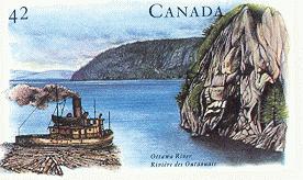
Stamp from September 2002 |
Published on
The Canadian Nuclear FAQ Cet essai est aussi disponible en français.
|